
Search East Pennsboro Township Streets
Use the street number and name to locate a particular parcel first. For East Pennsboro Township, Cumberland County’s Property Mapper and DataScout are place-based tools. They establish a situs address, parcel key, assessment facts, and an ownership clue. An East Pennsboro Township deed search then adds parties and a dated transfer record. A voter Street List is a separate, controlled election-record request, not a public browse tool. Historic directories can add a dated address clue only after the exact volume and its geographic reach are checked.
- For an East Pennsboro Township address, enter the exact address in Cumberland County Property Mapper, or use a known PIN. Click the matched parcel rather than relying on a nearby map label.
- Open the matching East Pennsboro Township address or parcel in Cumberland County DataScout. Record the owner as displayed, physical characteristics, assessed value, and the parcel number.
- For an East Pennsboro Township record, keep the PIN, UPI or tax-parcel number, situs address, and legal-description wording together. Those fields are the bridge when street text changes between systems.
- Use the East Pennsboro Township owner and document clues in Landex or ask the Recorder to locate the recorded instrument. Read the image or official index before treating a name as current.
- When a lawful election purpose supports it, use Pennsylvania’s formal request process for a Street or Walking List. For an East Pennsboro Township past-address question, ask CCHS or CCLS about a dated directory instead of assuming a current record reaches backward.
That sequence keeps East Pennsboro Township address research anchored to a property record. It also separates ownership, a recorded land transaction, and voter registration from claims about every person connected to an address. For a single name that must be checked against several kinds of records, the East Pennsboro Township resident lookup takes a different, person-first route.
East Pennsboro Township Street Directory Fields
Property Mapper is the county’s free map route for working down an East Pennsboro Township street one parcel at a time. Its quick-reference guide documents a SEARCH BAR for a street number and street name, with PIN as an alternative. The selected East Pennsboro Township parcel can be opened for detailed information, and the map supports pan, zoom, imagery layers, and a print widget. County materials describe the default 2024 imagery and seven earlier imagery years. Images can help locate a structure, but imagery does not identify a person.
| Mapper field or control | How it works | Street-directory value |
|---|---|---|
| SEARCH BAR | Enter East Pennsboro Township street number and street name | Finds the map location for a specific address. |
| PIN | Enter the county parcel identifier | Connects an East Pennsboro Township map result to assessment and recorded-land research. |
| Parcel click | Select the East Pennsboro Township property on the map | Opens the county-described detailed assessment information. |
| Pan, zoom, and imagery | Browse an East Pennsboro Township street segment or selected parcel | Provides parcel and built-environment context. |
| Print widget | Create an East Pennsboro Township map or selected-data printout | Preserves the visual reference used for the research log. |
Cumberland County DataScout is the companion East Pennsboro Township property-card route shown below. Its documented basic searches are address and parcel number.
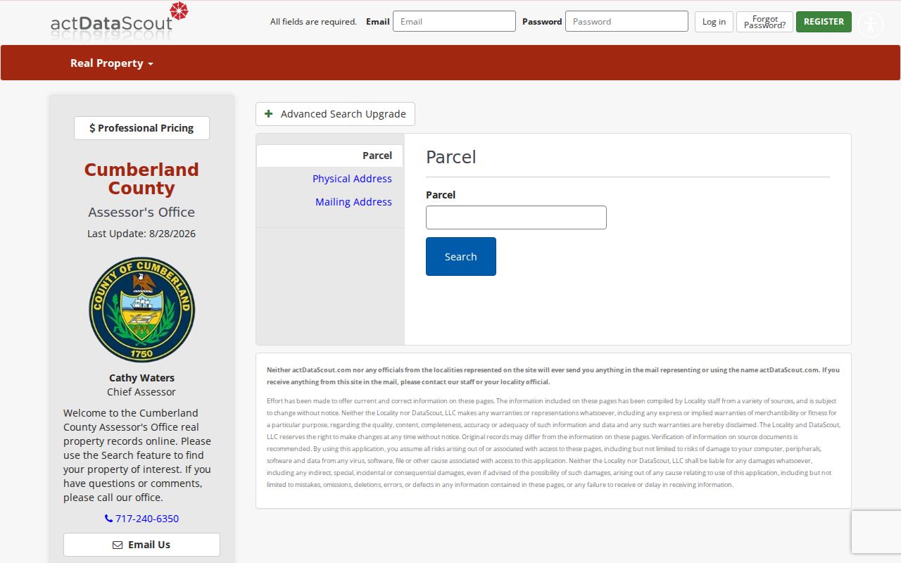
The DataScout route is useful after Mapper supplies an East Pennsboro Township place. County guidance says a card can show ownership, physical characteristics, and assessed value, while its advanced multiple-property and detailed-sales service is paid.
East Pennsboro Township Parcel Links
An East Pennsboro Township street string alone is fragile evidence. The county calls the map key a PIN, while Recorder guidance uses UPI or tax parcel number. Since October 1, 2008, selected real-estate conveyances, plans, mortgages, and other listed documents have required a tax parcel number on the first page. The same identifier often ties an East Pennsboro Township map selection to a recorded document. Older instruments may instead depend on the legal description, lot and block wording, acreage, adjoining owners, or a plan reference.
- Parcel or PIN
- A county land unit and its identifier. It is the most stable handoff between the map, Assessment, and many Recorder documents.
- Situs address
- The physical location of the parcel. It is not automatically an owner’s mailing location or a list of people present there.
- UPI
- Uniform Parcel Identifier, the tax-parcel reference required on specified Cumberland County real-estate documents from October 1, 2008.
- Legal description
- The recorded wording that identifies land by lot, plan, tract, acreage, boundaries, or other formal terms. It often outlasts an address change.
East Pennsboro Township assessment records are available for inspection at One Courthouse Square, Room 104, Carlisle, weekdays from 8:00 a.m. to 4:30 p.m. The office phone is 717-240-6350. The county says its online sources do not show some information, including owner mailing addresses. Ask Assessment for the needed parcel record rather than treating an absent online field as proof of anything.
East Pennsboro Township Street Directory Coverage
Each East Pennsboro Township address-keyed record answers a narrower question. Property systems describe a parcel and the owner shown on the assessment record. Land records establish dated document parties and transfers. Township files can show that an East Pennsboro Township address-specific permit or plan record may exist. Election lists have their own statutory request channel. Combining them carefully is more reliable than expecting one search to provide a full street roster.
| Address record | Custodian | What it can establish | Access path |
|---|---|---|---|
| Property Mapper | Cumberland County GIS for East Pennsboro Township | Parcel lines, map context, basic assessment data, imagery, and sales context | Free address or PIN map |
| DataScout card | Cumberland County Assessment for East Pennsboro Township | Ownership as shown, physical characteristics, and assessed value | Address or parcel search; Assessment counter for non-posted detail |
| Recorded land documents | Recorder of Deeds for East Pennsboro Township | Grantor, grantee, recording chronology, and land-description clues | Landex or Recorder counter |
| Township permit or plan file | East Pennsboro Township | Project, applicant or owner-agent, site, and dated administrative record when retained and public | Focused RTKL or counter request |
| Street or Walking List | Pennsylvania / Cumberland Elections for East Pennsboro Township | Defined voter information under the request form | Controlled electronic request, not online browsing |
For East Pennsboro Township, Property Mapper supplies the visual parcel start, DataScout supplies a card, and the PIN or legal description carries the research to land records. A public map popup is not a mailing-address directory. It is also not evidence about unlisted members of a household.
Deeds Along East Pennsboro Township Streets
The Cumberland County Recorder of Deeds maintains the East Pennsboro Township land-record trail. County public-record guidance states deeds run from 1750 to the present, mortgages from 1973 to the present, and miscellaneous records from 1956 to the present. An East Pennsboro Township address can lead to the owner displayed on a property card, then to an acquisition record where that owner is the grantee. The seller named there becomes the next backward search as grantee. That is a title method, not a claim that the named parties occupied the property.
Landex is the county’s 24-hour East Pennsboro Township deed-search route and is pictured here.

For an East Pennsboro Township deed, use a narrow recording-date range, party role, document type, book or instrument reference when known. Landex describes its Webstore as a browser search with online document payment, while Remote is time and page billed. If the required image or notation is unclear, the Recorder counter at 1 Courthouse Square, Carlisle, offers search and review during its posted hours. The Recorder’s phone is 717-240-6370.
Note: A recording date and a deed execution date can differ, so retain both only when the instrument itself provides them.
East Pennsboro Township Voter Records
Pennsylvania does not provide an open state webpage for browsing everyone registered along an East Pennsboro Township street. The public individual-status route is designed for a voter to check registration, while the state voter-list form governs bulk information. Cumberland County Elections allows public inspection of East Pennsboro Township voter-registration records under staff supervision, and the office is at 1601 Ritner Highway, Suite 201, Carlisle, 717-240-6385, weekdays from 8:00 a.m. to 4:30 p.m.
The state form offers electronic Public Information, Street, Walking, and Full Voter Export lists at $20 per county per list. For East Pennsboro Township, a Street List has name, residential and mailing address, party, and active or inactive status; a Walking List omits mailing address. The requester supplies identification and signs an affirmation. Under 25 Pa.C.S. §§ 1207(b) and 1404(c)(2), the form limits use to the stated election, political-activity, or law-enforcement purposes and bars commercial or unrelated use. The regulations also bar publishing the East Pennsboro Township files online.
For that reason, an East Pennsboro Township controlled list is a lawful custodial channel, not content for a public roster. A registration status for an East Pennsboro Township voter can change after a move, a name change, or a party change. Contact Pennsylvania’s voter-registration service or the county office for the official status route instead of relying on an old record.
Township Files by East Pennsboro Address
East Pennsboro Township’s zoning-permit application has fields for the site address, owner information, applicant, work description, zoning district, parking and setback entries, and a conditional site plan. Those fields show why an East Pennsboro Township municipal address record may exist. The township has not published searchable permit-result records. A permit application is also evidence of an application or project, not proof that a person lives at the site now.
A focused East Pennsboro Township request is the documented fallback. The township’s Right-to-Know form lets a requester choose electronic or printed copies, inspection, certification, and a cost-notification limit. Identify the East Pennsboro Township address, a practical date range, and the record category, such as a zoning-permit application or final decision. The form records a five-business-day response due date and an optional 30-day extension. The Township office is at 98 South Enola Drive, Enola, and its main phone is 717-732-0711.
Request narrowly. A named East Pennsboro Township address, date window, and permit or plan category give the open-records officer a record to locate without asking the Township to create a person profile.
South Enola Numbers Changed
East Pennsboro Township address continuity has a local trap. A 2015 county public-safety review described a proposed readdressing of 20 locations after two locations shared “600 South Enola Road.” Preserve the number exactly as it appears in each East Pennsboro Township record and add the document date to the research log. Do not mechanically substitute a modern map result for an older number.
East Pennsboro Township also has several useful place terms. Enola developed around the rail yard, Summerdale is associated with 1909 growth, and West Fairview is the East Pennsboro Township riverside village represented by a 1910 Sanborn map set. An old directory, map, or deed may use one of those terms rather than the current township label. Search the village name as well as East Pennsboro Township, then compare parcel, legal description, and dated map context before joining records.
East Pennsboro Township postal labels are separate from township jurisdiction. Enola 17025 is common in official Township addresses, while county sources also show East Pennsboro Township locations with Camp Hill 17011 labels. Use USPS ZIP Code Lookup to check an East Pennsboro Township delivery address, but use Mapper, DataScout, or county precinct context to confirm the municipality.
East Pennsboro Township Street Directory Limits
East Pennsboro Township property sources do not promise a list of everyone at an address. DataScout and Property Mapper lead to property facts and ownership as shown, and county guidance specifically warns that online sources may omit information such as owner mailing addresses. The East Pennsboro Township election process is controlled. Permit files can be exempt in part or unavailable in a requested form. A missing entry should never be read as a reason to search for a protected address by other means.
Pennsylvania’s Address Confidentiality Program permits qualifying survivors to use a substitute address in defined East Pennsboro Township voter, court, vehicle, school, marriage-license, utility, and other records. Driver-address information is protected by the federal Driver’s Privacy Protection Act. The right approach is to accept those limits, document only the minimum parcel or record reference needed for a lawful purpose, and verify a questionable entry with its custodian.
Lawful personal use. Use East Pennsboro Township street records for personal, family-history, property, or civic research. Pennsylvania harassment and stalking laws, 18 Pa.C.S. §§ 2709 and 2709.1, still apply to unwanted contact, surveillance, threats, or intimidation.
East Pennsboro Township Historic Streets
An East Pennsboro Township past address needs a dated source, not a guess drawn from a present parcel card. The 1910 West Fairview Sanborn set has five sheets and can place an East Pennsboro Township building, street, block, use, and nearby infrastructure at one moment. It documents the built environment, not a roster of inhabitants. Pair such a map with a deed, census, tax record, newspaper, or a directory whose coverage has been confirmed.
The East Pennsboro Branch Library can route East Pennsboro Township catalog and research-database questions, while the Cumberland County Historical Society in Carlisle holds East Pennsboro Township genealogy files, manuscripts, newspapers, church and cemetery materials, and other county sources. Exact historical directory years for the township were not verified as an uninterrupted run. The East Pennsboro Township city directory collections identify the documented regional titles and the archive route for a date-specific household question.